
Finding Fresno County Street Records
A street-by-street search starts with one complete address. Fresno's basic property form accepts the site number, direction, street name, and city, or a segmented APN. It does not offer an owner-name field. That design makes the address the bridge to a parcel, while the APN becomes the bridge to other custodians. Keep a research row for each parcel so a long street does not blend two similarly named roads or two legal descriptions.
The goal is to separate ownership evidence from household evidence. A situs address is the physical place. A tax mailing address is where assessment notices go. A deed is indexed by party and instrument. A directory entry is limited by the publisher's coverage. A voter record is controlled by California access rules. The following order keeps those differences visible.
- Resolve the address. Run the number, direction, street name, and city through the Fresno County Assessed Value Lookup, then save the complete APN and situs text.
- See the parcel shape. Open the Fresno County GIS Portal and the assessor or recorded-map viewer. Note lot, block, subdivision, and adjacent APNs.
- Identify the current title party. Use the assessment roll, counter route, or most recent recorded deed. Do not turn a mailing address into proof of occupancy.
- Carry the party into the deed index. Search the current name as grantee, narrow the date and document type, and read the image or legal description.
- Add household context. Use the Haines Criss-Cross collection from 1973 forward and older Polk directories where the year and geographic footprint fit.
Fresno County Address Search Fields
The Fresno County Assessed Value Lookup is the most dependable public starting point for a current street record because its form is built around a parcel or situs address. Enter the address as the county presents it. A directional prefix, a community selection, and a street-name variant can change the result. Rural and foothill locations may use a community name or route description that does not match a city street grid.
| Parcel Number | Alternative segmented numeric input, such as 423-284-37; retain any suffix shown. |
|---|---|
| Street # | House or site number for an address search. |
| Direction | Optional dropdown for a directional prefix. |
| Street Name | Name field used with the number and direction. |
| City | Optional county-community selection; postal and legal jurisdiction may differ. |
The result can expose APN, situs, assessment-roll year, values, and a map path where the interface provides them. The assessment is not a market appraisal. Owner or mailing details can depend on the roll product and counter access. If the web form returns no match, check spelling, direction, city, parcel suffix, the county map viewer, or the Assessor office at 2281 Tulare Street, Room 201. The Fresno County Assessor resources page explains the office's mapping and roll channels.
Fresno County Records by Address
The Fresno County street directory is assembled from records that have different access rules and different meanings. The table below keeps a parcel map from being mistaken for a resident list. A Fresno County street directory search can show an owner, a named party, a permit applicant, or a historical listing. It cannot promise that every household member appears.
| Record Set | Keeper | What It Shows | Access |
|---|---|---|---|
| Assessment roll and situs index | Fresno County Assessor | APN, situs, assessed facts, mailing route | Web, files, or counter |
| GIS parcel layer | County GIS and related viewers | Boundaries, adjacent APNs, layers and districts | Free online viewers |
| Deed and official-record index | Fresno County Recorder | Titled parties, instrument type, date and legal description | Free index, copies paid |
| Permit or code file | City or county planning | Project scope, applicant, dates, status and address | FAASTER, paper files, or request |
| Criss-cross directory | Fresno library | Listed address, occupant and telephone sequence | Onsite collection |
The APN links the assessment record to recorded maps and deeds. The street name helps locate the parcel, but it is not a reliable Recorder search key. For a whole road, repeat the parcel workflow one number at a time or use the county's downloadable street situs and assessment resources when the current office provides them. Tax status and payment questions follow the Fresno Tax Collector property-tax route, not the Recorder's deed index.
Fresno County GIS Parcel Layers
Open the Fresno County GIS Portal, search the address or APN, zoom to the subject polygon, and select the parcels that touch or face it. For a Fresno County street directory search, retain the map date and layer names beside the parcel result. Turn on address, parcel, aerial, jurisdiction, zoning, flood, and district layers only as needed. GIS is the geography bridge. The Assessor and Recorder remain the better sources for assessment facts and title parties.
For a map book or recorded subdivision, use the separate assessor and Recorder viewers. The Assessor Map Lookup accepts book, page, roll year, index-page choice, index type, and index page number. Recorded Map Lookup accepts book and page plus map types such as tract subdivision, parcel, records of survey, miscellaneous maps, assessment district, precise plan line, and floodway or highway-related plans. Those maps establish geometry, easements, lot lines, or street relationships. They do not establish who occupies a parcel.
The recorded-map entry screen at Fresno County Recorded Map Lookup shows the book, page, and map-type route.
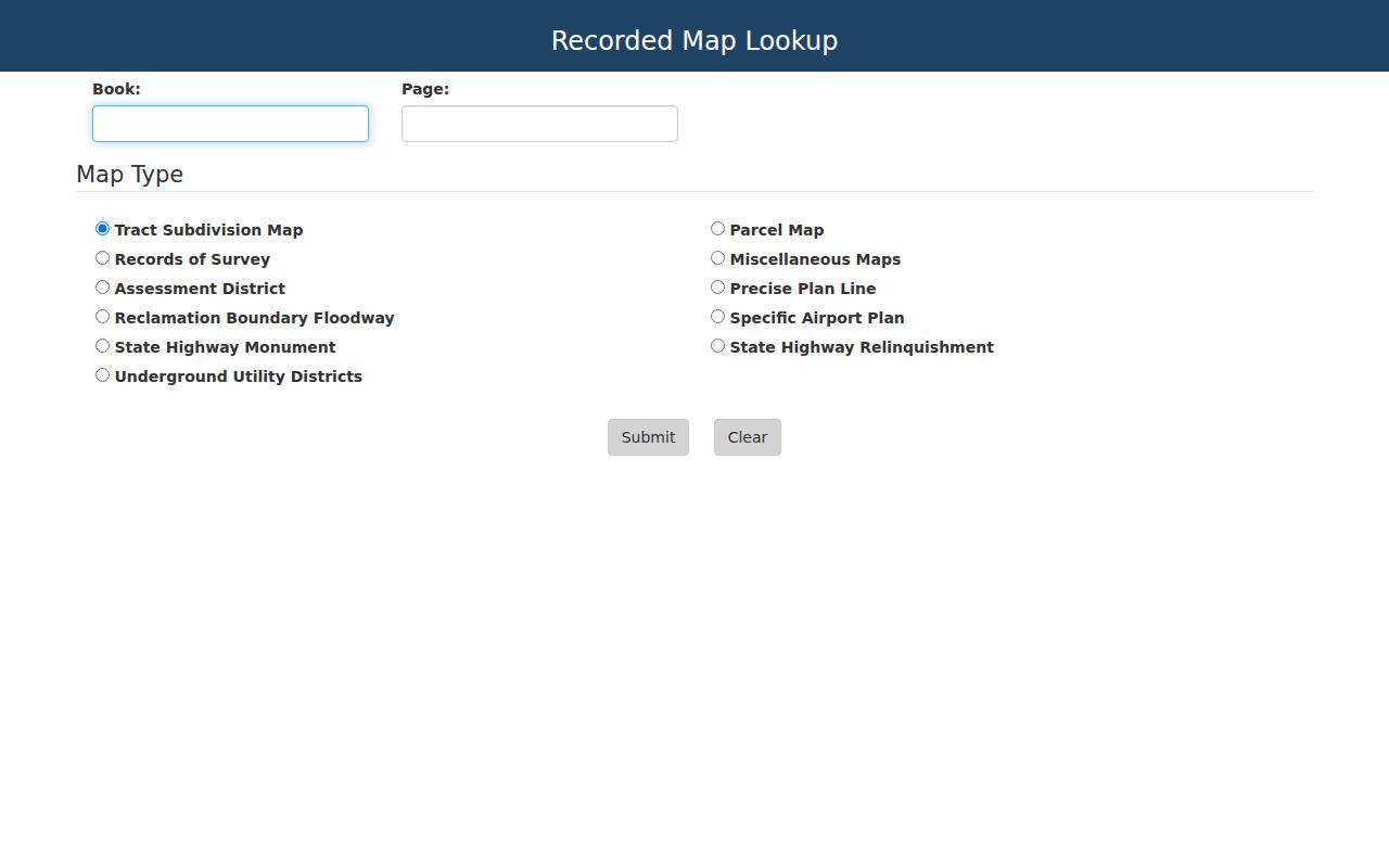
A recorded map is useful when a modern street label hides an older tract or parcel relationship. Carry its book and page into the deed or assessor record.
Fresno County Deeds Along a Street
Recorded deeds usually search by party name, document type, date, instrument number, legal description, or book and page. A street address may be absent or appear only inside the image. Start with the APN and current title party from the assessment or newest deed. In the Recorder's searchable index, choose grantor or grantee when the portal offers that control, narrow the date range, and inspect the document rather than relying on the result row.
To walk backward, treat the seller named in the current acquisition deed as the next grantee to search. Copy the grantor, grantee, recording date, instrument number, APN, and legal description into the parcel row. Repeat until the online index reaches 1981. Then change tools: scanned deed indexes cover 1856-1913, separate grantor and grantee books cover 1914-1971, and combined books cover 1972-1980. The Recorder's recorded-document instructions describe the historic browse and copy routes. Pre-1981 copies need a party, document type, year, and book or page when known.
A reconveyance is a loan release, not a transfer of ownership. A quitclaim may change an interest without a normal sale. A legal description and APN are stronger bridges than a street label, especially where a parcel was split, annexed, or renamed.
Fresno County Permits by Address
Planning and permit files add a different layer to a Fresno street directory. Within the City of Fresno, FAASTER and planning records can expose searchable building, planning, and public-works documents. Older Building & Safety material may remain in paper or microfilm address files. County Planning handles unincorporated parcels. Use GIS to confirm the legal jurisdiction before sending a request because a Fresno postal label does not decide which department owns the file.
A permit may list an applicant, contractor, owner or project contact, work description, parcel, dates, inspections, and status. Those names show who interacted with a project. They do not by themselves show who lived at the address. For an older file, name the site address, APN, approximate year, permit or project number if known, and the exact records wanted, such as the permit card, inspection history, or plan index.
City records requests should describe an existing identifiable record. Plans may have access, copyright, or security limits even when a permit index is open. Pair the permit date with the deed chain, maps, and directory entry before saying that a building or household changed.
Fresno County Maps, Plats, and Names
Fresno County's historical map shelf helps translate an old street into a modern parcel. The library lists a 1891 county atlas, a 1907 atlas, Guard atlases from 1909, 1911, and 1913, Progressive atlases from about 1920 and 1935, a Real Estate Atlas from 1966-1981, and Agri-Land material from 1978-2007. Fresno State MALT aerial flights from 1937-1999 can show when a structure or subdivision appeared.
A 1939 Fresno city block-book set noted by the Historical Landmarks & Records Commission may bridge older lot references to current APNs. Ask the library for the volume and coverage before relying on an example. Sanborn maps can add building footprint, use, construction material, and old street-name context, but the exact town and sheet year must be checked in the catalog.
Address continuity is fragile. Renamed streets, annexation, rural-route conversion, changed directional prefixes, and subdivision marketing names can all break a simple text search. No official countywide table establishes one universal renumbering year. Verify an old address in the city block books, directories, assessor maps, and ordinances for that particular location.
Reading Fresno County Criss-Cross Directories
Haines Criss-Cross provides countywide address-oriented coverage from 1973, with related regional coverage that includes Madera, Kings, and Tulare Counties. Unlike an alphabetical name directory, a criss-cross sequence lets a researcher enter by street and number, then read the listed person or telephone information. It is valuable for a past household or nearby address, but publication gaps, privacy choices, and changing coverage still matter.
Older Polk-Husted or R.L. Polk volumes should be chosen by year and geography. Polk began its familiar Fresno run in 1907, covered all or most of the county through 1957, then narrowed to Fresno city. Clovis returned in 1973. The correct volume may therefore be the difference between a useful hit and a false absence. The Fresno County city directory collection explains the publisher changes and the shelf method in more detail.
Read the abbreviation key first. An entry can include a surname, given name or initial, spouse in parentheses, occupation, listed business, residence address, and a homeownership mark. A missing name can mean a move, a no-telephone listing, a rural exclusion, a nonpublication year, or a different address form.
Fresno County Street and Jurisdiction Traps
Fresno County combines a dense county seat, incorporated cities, agricultural communities, foothills, and mountain locations. A downtown Fresno address, a Clovis subdivision, a west-side farm community, and a Sierra parcel do not leave the same paper trail. Fig Garden can illustrate a city and unincorporated boundary question. Pinedale has a 93650 postal identity within north Fresno context. Postal city, legal jurisdiction, census place, and assessor parcel are separate labels.
Use the County GIS and the City GIS data layers to decide whether a permit, code case, or public-record request belongs to the City of Fresno or a county department. Use USPS only for delivery verification. For agricultural parcels, property atlases, irrigation or business files, agricultural credentials, and aerials may reveal more continuity than a residential directory.
Keep the jurisdiction beside each result. A Fresno County residents directory entry without a city, date, APN, or source title is too thin to carry a street-history conclusion.
What the Fresno County Street Directory Misses
A street directory cannot show every person connected with a parcel. Property records focus on title, assessment, or a mailing route. Deeds focus on named parties. Permits focus on a project. Haines and Polk show only the people their publisher listed. Current voter information is an authenticated self-lookup or a qualified-purpose file, not a public block browser. DMV, utility, delivery, and private customer data are not open substitutes.
For an identifiable county record that is not on a portal, use the Fresno County public-records request channel with a date range, address or APN, department, and requested record type. A request can locate an existing record, but it cannot create a resident list or override a confidentiality rule.
A mailing address can belong to a trustee, business, or remote owner. A permit applicant can be a contractor. A directory entry can be stale. To verify one person, save two independent records and use the full name, date, city, APN, legal description, or public role as the matching clue. When the goal shifts from a whole street to one individual, the Fresno County resident lookup workflow gives the narrower record sequence.
- Parcel
- A mapped piece of land identified by an APN.
- Situs address
- The physical location of the parcel, distinct from a tax mailing address.
- Plat
- A recorded map showing lots, blocks, streets, or easements.
- Criss-cross directory
- An address-order reference that can connect a street number with a listed name or telephone entry.
Lawful use. Fresno County address records are suitable for personal research, family history, property curiosity, and civic questions. Do not use a street directory to stalk, harass, intimidate, or harm anyone.